


Washington County--St. George City PUMA, Utah
About
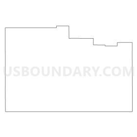
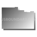
Outline
Summary
| Unique Area Identifier | 194241 |
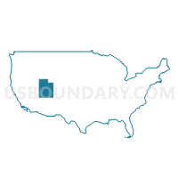
| Name | Washington County--St. George City PUMA |
| State | Utah |
| Area (square miles) | 2,429.95 |
| Land Area (square miles) | 2,426.36 |
| Water Area (square miles) | 3.59 |
| % of Land Area | 99.85 |
| % of Water Area | 0.15 |
| Latitude of the Internal Point | 37.26253080 |
| Longtitude of the Internal Point | -113.48780030 |
Maps

Graphs
Select a template below for downloading or customizing gragh for Washington County--St. George City PUMA, Utah


Neighbors
Neighoring Public Use Microdata Area (by Name) Neighboring Public Use Microdata Area on the Map
- Mohave & La Paz Counties--Lake Havasu City PUMA, AZ
- Rural Nevada PUMA, NV
- Southwest & South Central Utah (Outside Washington County)--Cedar City PUMA, UT
Top 10 Neighboring County (by Population) Neighboring County on the Map
- Mohave County, AZ (200,186)
- Washington County, UT (138,115)
- Iron County, UT (46,163)
- Kane County, UT (7,125)
- Lincoln County, NV (5,345)
Top 10 Neighboring County Subdivision (by Population) Neighboring County Subdivision on the Map
- St. George CCD, Washington County, UT (110,091)
- Cedar City CCD, Iron County, UT (40,899)
- Hurricane CCD, Washington County, UT (25,701)
- North Mohave CCD, Mohave County, AZ (10,851)
- Kanab CCD, Kane County, UT (5,697)
- Pioche CCD, Lincoln County, NV (2,684)
- Enterprise CCD, Washington County, UT (2,323)
- Orderville CCD, Kane County, UT (1,428)
- Beryl-Newcastle CCD, Iron County, UT (1,313)
- Caliente CCD, Lincoln County, NV (1,263)
Top 10 Neighboring Place (by Population) Neighboring Place on the Map
- St. George city, UT (72,897)
- Washington city, UT (18,761)
- Hurricane city, UT (13,748)
- Ivins city, UT (6,753)
- Santa Clara city, UT (6,003)
- Colorado City town, AZ (4,821)
- La Verkin city, UT (4,060)
- Hildale city, UT (2,726)
- Enterprise city, UT (1,711)
- Toquerville town, UT (1,370)
Top 10 Neighboring Unified School District (by Population) Neighboring Unified School District on the Map
- Washington School District, UT (138,115)
- Iron School District, UT (46,163)
- Kane School District, UT (7,125)
- Colorado City Unified District, AZ (6,133)
- Lincoln County School District, NV (5,345)
- Littlefield Unified District, AZ (3,930)
- Fredonia-Moccasin Unified District, AZ (2,825)
Top 10 Neighboring State Legislative District Lower Chamber (by Population) Neighboring State Legislative District Lower Chamber on the Map
- State House District 3, AZ (216,687)
- Assembly District 36, NV (59,012)
- State House District 71, UT (51,723)
- State House District 74, UT (47,422)
- State House District 72, UT (40,624)
- State House District 75, UT (36,038)
- State House District 73, UT (34,070)
Top 10 Neighboring State Legislative District Upper Chamber (by Population) Neighboring State Legislative District Upper Chamber on the Map
- State Senate District 3, AZ (216,687)
- State Senate District 29, UT (120,802)
- Rural Nevada Senatorial District, NV (97,335)
- State Senate District 28, UT (94,905)
Top 10 Neighboring 111th Congressional District (by Population) Neighboring 111th Congressional District on the Map
- Congressional District 2, AZ (972,839)
- Congressional District 2, UT (890,993)
- Congressional District 2, NV (836,562)
Top 10 Neighboring Census Tract (by Population) Neighboring Census Tract on the Map
- Census Tract 2708.01, Washington County, UT (13,516)
- Census Tract 9501, Mohave County, AZ (10,851)
- Census Tract 2711, Washington County, UT (10,304)
- Census Tract 2709.02, Washington County, UT (10,113)
- Census Tract 2707, Washington County, UT (9,725)
- Census Tract 2701, Washington County, UT (8,839)
- Census Tract 2703, Washington County, UT (8,148)
- Census Tract 2717.01, Washington County, UT (8,094)
- Census Tract 2706, Washington County, UT (7,724)
- Census Tract 2705, Washington County, UT (7,423)
Top 10 Neighboring 5-Digit ZIP Code Tabulation Area (by Population) Neighboring 5-Digit ZIP Code Tabulation Area on the Map
- 84770, UT (39,131)
- 84790, UT (35,770)
- 84720, UT (19,705)
- 84780, UT (18,756)
- 84737, UT (14,838)
- 84738, UT (6,878)
- 84765, UT (6,143)
- 86021, AZ (6,085)
- 84741, UT (5,556)
- 84745, UT (4,066)